Between August 2025 and July 2026, Brazil's satellite alert system flagged 2,874 square kilometres of Amazon clearing. That is roughly a third less than the year before, and something over half below the average of the preceding decade. It is the lowest figure the alert system has recorded since 2013.
Coverage has framed this as potentially the lowest official rate since national monitoring began in 1988. That framing needs one correction. The official survey's own record low is 4,471 square kilometres, set in 2012. Beating 1988 means beating 2012 — plausible, given where the alerts sit, but not yet demonstrated.
This is one of the largest environmental improvements anywhere in the world right now. It received a fraction of the coverage that a comparable deterioration would have.
That asymmetry is worth examining, but it is not the most interesting thing here. The most interesting thing is what the number can and cannot see.
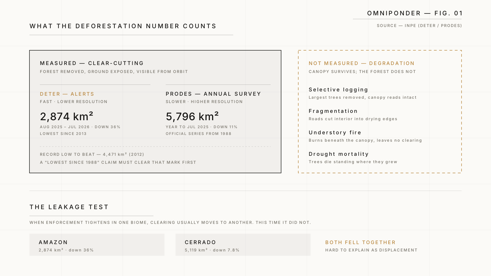 Caption: Two measurement systems, and the forms of forest loss that neither was built to count.
Two Systems, Routinely Confused
Brazil measures its forest twice, with instruments built for different jobs. Almost every confused headline about the Amazon comes from treating the outputs as interchangeable.
DETER is the alert system. It scans frequently and reports fast, feeding enforcement teams something close to real time. Speed is bought with resolution: it is a tripwire, designed to send officers to a place, not to produce a definitive account of hectares lost.
PRODES is the annual survey. Higher resolution, slower, more careful, published once a year for the twelve months ending in July. It is the official number, the one that enters the historical series stretching back to 1988.
The 2,874 square kilometres is a DETER figure. The most recent PRODES number covers the year ending July 2025: 5,796 square kilometres, down 11 percent, the lowest in eleven years.
The two are not contradictory. They are different instruments pointed at the same forest, and the gap between them is mostly resolution, not disagreement. But the distinction matters for how much confidence the moment deserves. The alerts are strongly encouraging. The official confirmation has not yet been published.
A tripwire and a census will not return the same number, and treating either as the other produces false alarm or false comfort.
What Actually Caused It
The decline coincides with a deliberate policy shift: enforcement operations resumed at scale, monitoring capacity rebuilt, protection of Indigenous territories restored as an active programme, and targeted agreements with the specific municipalities where clearing concentrates.
None of that is technologically novel. There is no breakthrough here, no new satellite, no invention. It is the state doing unglamorous things consistently — showing up, issuing fines, seizing equipment, following through on land designations, and being seen to do so.
That ordinariness is the finding. A problem widely narrated as civilisational and intractable turned out to respond, quickly, to enforcement. It did not require a change in global appetite for beef or soy. It did not wait for a treaty. It required a government that decided to act and possessed enough institutional capacity to do it.
The corollary is uncomfortable and should be stated plainly: if the improvement came from policy choices, it can be reversed by policy choices. Nothing structural has been fixed. What changed is who is enforcing, and how hard — and Brazil has already demonstrated, once, how quickly that can change back.
Brazil Has Done This Before
The most useful thing to know about this moment is that it is not the first one.
Between 2004 and 2012, Brazil cut Amazon deforestation from 27,772 square kilometres a year to 4,471 — a decline of roughly eighty percent, achieved through much the same combination now in use: enforcement, satellite monitoring, new protected areas, supply-chain pressure, and a favourable economic period. At the time it was widely described as one of the great environmental achievements of the century, and the description was fair.
Then it came apart.
Deforestation rose 28 percent in the year to July 2013 and trended upward for most of the following decade. The reversal was not caused by a technological failure or a collapse in enforcement capability. It was substantially legislative: a 2012 revision of the Forest Code reduced the protection required on private land and granted amnesty for clearing carried out before 2008, alongside the rising political weight of a landowning and agribusiness bloc with a direct interest in loosening restrictions.
The forest did not lose its protections because they stopped working. It lost them because they were repealed.
This is the precedent against which the current decline should be read. It tells us the mechanism is real — enforcement genuinely works, and it works fast. It also tells us that the gains sit on a political foundation and can be legislated away in a single session, while the forest they protect takes centuries to grow.
The Test That Makes This Credible
Here is the detail that separates a real result from a statistical illusion, and it is the part most coverage skipped.
When enforcement tightens in one biome, clearing frequently moves to another. The pressure has to go somewhere: it relocates to a jurisdiction with fewer inspectors, weaker protections, or less international attention. Environmental economists call this leakage, and it is the standard reason to distrust a sudden regional improvement.
Brazil's obvious candidate for leakage is the Cerrado — the vast tropical savanna south and east of the Amazon, less charismatic, less protected, and the country's agricultural frontier. For years, Amazon gains were partly Cerrado losses.
That is not what happened. Cerrado alerts also fell over the same period, down about 8 percent, to their lowest total in five years.
Both went down together. That is much harder to explain as displacement, and much easier to explain as a genuine reduction in clearing activity.
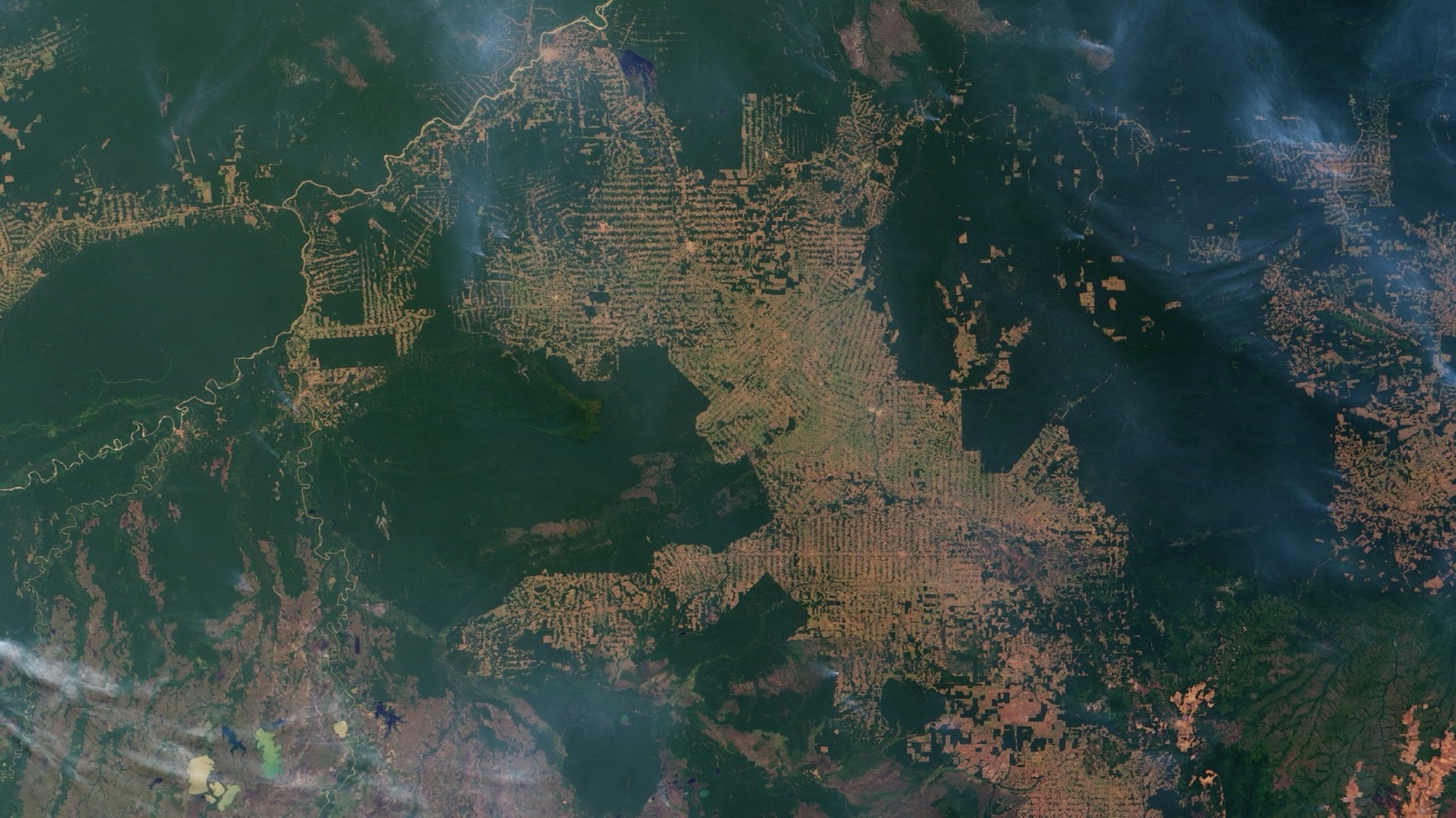 Caption: Clearing advances along roads in northwest Rondônia, Brazil — the fishbone pattern satellite alerts are built to detect. NASA Earth Observatory image by Jesse Allen and Robert Simmon, using MODIS data from the Terra satellite, 2007.
What the Number Cannot See
Now the harder part.
Deforestation, as these systems measure it, means clear-cutting: forest removed, ground exposed, a visible change in what the satellite sees from above. It is a good metric precisely because it is unambiguous.
But a forest can be substantially destroyed without being cleared.
- Selective logging removes the largest, most valuable trees while leaving canopy that reads as intact from orbit.
- Roads and fragmentation cut continuous forest into islands, and edges dry out, burn more readily, and support less life than interiors.
- Fire moves through the understory of a degraded forest without necessarily producing a clearing.
- Drought — increasingly severe, and partly driven by deforestation elsewhere — kills standing trees where they stand.
Researchers describe the combined effect as degradation, and its trajectory is not following the deforestation curve downward. Logging, roads, fragmentation and hotter, drier conditions are turning large stretches of standing forest into something closer to tinder — moving the system toward an equilibrium in which fire and degradation matter as much as the chainsaw.
So it is entirely possible for Brazil to post its best clear-cutting number since 1988 while the forest's actual resilience continues to decline. Both statements can be true, because they are measurements of different things.
The metric improving is not the same as the system recovering. Deforestation is what we chose to count, not the whole of what is happening.
This is not an argument for dismissing the achievement. It is an argument for knowing its shape.
Why Good News Is Structurally Invisible
There remains the question of why the largest environmental improvement in years passed with so little attention.
Part of the answer is ordinary news economics: deterioration is an event, improvement is a trend, and trends do not have a Tuesday on which they happen. A forest cleared is a photograph. A forest not cleared is an absence, and absences are unphotographable.
Part of it is that our attention is calibrated to threat. This is not a media failing so much as an inheritance — the same asymmetry that makes a single alarming statistic travel further than a reassuring one, and that made vigilance adaptive long before it made us anxious. It is one of the more consistent findings about how people process information, and it shapes what a society believes about its own trajectory.
The consequence is a distorted picture in a specific direction. If improvements are systematically under-observed while deteriorations are amplified, a population can come to believe that nothing works — that every environmental problem is a ratchet turning one way. That belief is itself consequential. It makes enforcement look futile when enforcement is in fact the thing that worked.
What Follows
Policy capacity is the variable. The Amazon did not improve because the underlying economics changed. It improved because a state chose to enforce and was capable of enforcing. That is a more hopeful finding than a technological fix, and a more fragile one.
Measure the thing you actually care about. If the goal is a functioning forest rather than an unbroken canopy in satellite imagery, then degradation, fire and drought belong in the headline number. What gets counted gets managed, and what escapes counting escapes management.
Distrust improvements that are not tested for leakage. The Cerrado holding steady alongside the Amazon is the single most persuasive detail in this data, and it is the one that went almost entirely unmentioned. Examining the structure beneath a headline number is the whole of what we do here.
The number that came out this month is genuinely good news, arrived at by unremarkable means, and it deserves to be known. It is also a partial view of a system under strain from directions the number was never built to detect.
Both of those are worth holding at once. Refusing the good news is not rigour, and mistaking it for the whole picture is not either.